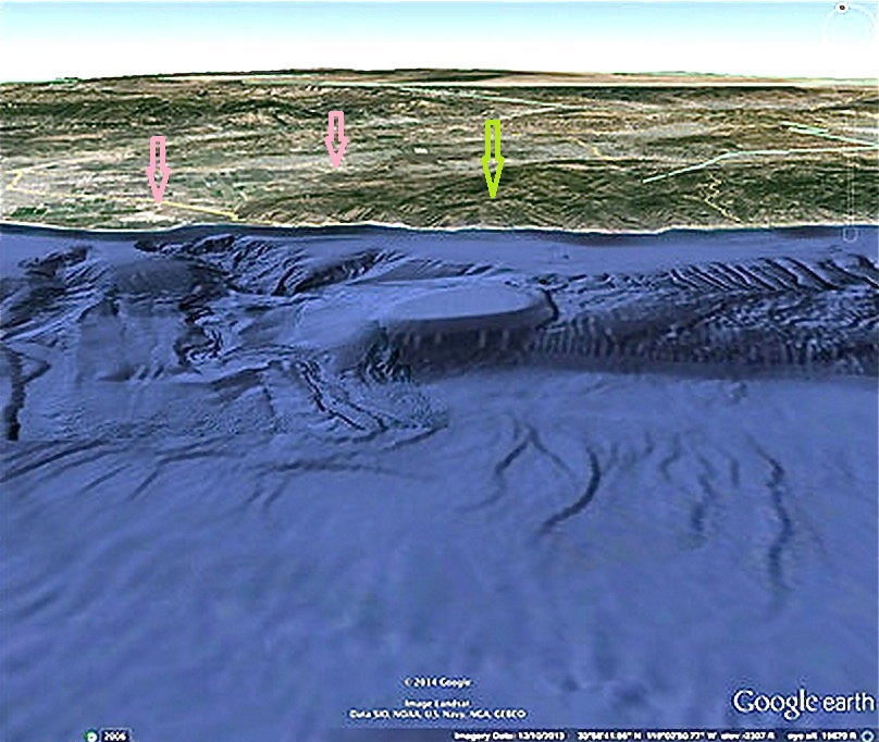
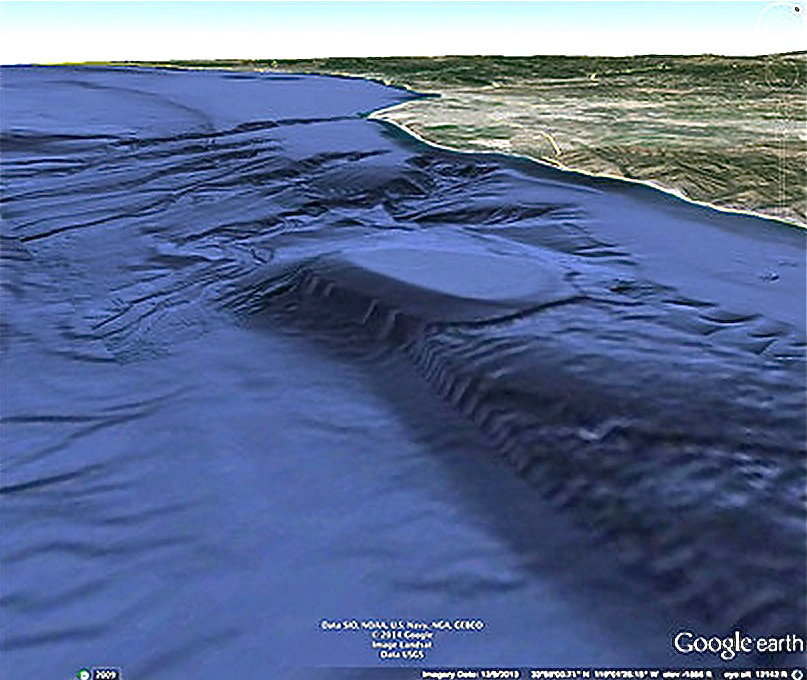
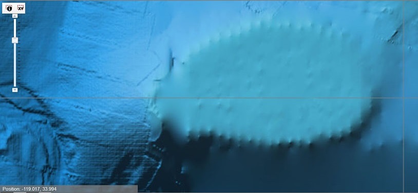
This massive triangular pillard structure lies six miles out off Point Mugu on the coast of Malibu in southern
California and its' pillars are well over 635 feet high. It not only is situated directly across from Point Mugu State
Park, green arrow. Point Mugu Naval Air Station is located on the coast right across from it also, pink
arrows.
It's also been
said that U.S. submarines have investigated a long tunnel found inside the structure, but never returned. No updates
nor information has been given out on this. Others state that the U.S. Navy built the structure in
the 1940s for submarine housing, and others claim that it is all just a Google PhotoShop hoax to fool and decoy
researchers from an underwater submarine base, and that Google manipulates many of its' maps, and the reality is,
the supposed structure is not really there at all, but is only a large underwater out-cropping with
erosion lines that look like pillars?
But, if the structure is real, then when looking closely at the pillars, they are bent or jointed
and extend out as roof supports that travel several miles near to, and south along the mainland for miles, but
show no barnacles nor sea life growing on them. The structure was once above or at sea level,
but with ice age melts and California seismic activity, it is now 2,000feet below sea level. If this
structure was once at sea level, it shows the sea has risen many more hundreds of feet than the three to four hundred
roughly estimated. There are also mysterious archaic stone structure ruins up in the hills.
The Chumash Indians who live in the area claim the geoglyph structures there were built by the first peoples millennia ago,
who were then washed away by great tidal waves. The coast of Malibu California, the Naval Air Station and State Park
can clearly be seen in the background along the light strip of beach sand.
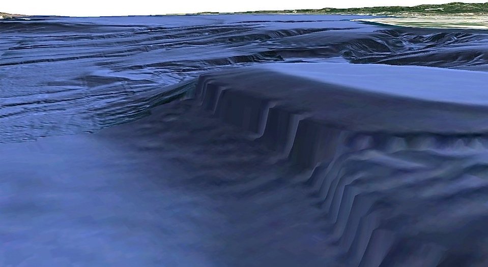
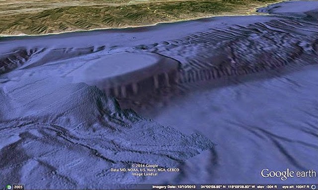
This view looking north-eastward shows the pillars
looking like gargantuan beetle-bug legs and feet that extend at the bottom at an angle, continuing under a line of
sand while also continuing southward aligned close together like roofing covered with sand and mud, and appearing
like a parking garage or pavilion.
Looking over the top of the triangular structure shows the flat, long roof-like beams
or ribs continuing with shifting sands covering and uncovering parts of them. The triangular pavilion also has pillars neatly
and geometrically aligned along its' east side. A smooth, tight tarp seemingly appears stretched over its' top.
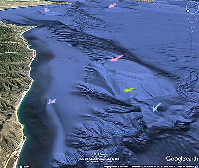
But some things do look PhotoShop covered in these photos. Not only are there rectilinear line formations, lt.
grey arrows in the sands, there are strange geometrical cut-out lay-overs, lt. blue arrows placed on the
north end of the squared area the pavilian sits in, and an odd patch right next to it, lt. green arrow.
The entire surrounding area does not match the pavilion's terrain in any way and looks like a large PhotoShop 'cut-out'
patch, or man-made parcel of it's own. Also, southward and further out is a sunken triangular area in the sand which shape
is a perfect match to the triangular pavilion in the foreground and looks like it could be another pavilion that might once
have been connected to it, pink arrows, unless it too, is just another Google PhotoShop creation?
This view looks down on the un-natural squarish, cut-out looking area the triangular pavilion
appears to be embeded in, with a major crack of erosion around it's southern end. It also shows some ribs or beams
along the eroded coast, covered in thick, muddy-like blobs.
Looking again to the north shows the pillars and the strange squarish shaped cover area around
the pavilion. There appears to be a tight fitting covering over this entire area, as well as smooth and textured
areas looking like cover-overs that do not match the surrounding terrain.
Looking again to the southeast. People claim they've watched the lights of UFOs at night flying
over this pavilion area at Point Mugu, and that UFOs fly into the ocean there and disappear. But where do they go?
Everything appears inundated and covered in sands that come and flow in with the tidal currents. There is also the
Point Mugu Naval Air Station on the beach who have a patrolled air and sea space weapons testing area of 36,000
square miles there, along with all its' helicopters, airplanes, jets, proto-types, submarines, test flights, missile
launches, along with their buildings and hangers which can be seen in the very top photo, orange arrows.
Hardly any space or place there for an alien underwater UFO base supposedly hidden out-of-sight even if digitally
covered over?
Is it possible the U.S. Naval Air Station's night flying aircrafts' lights reflecting on tossing and dipping ocean
waves could give the appearance of dipping UFOs disappearing into the ocean if an observer is watching the lights
thinking they are underwater spacecraft?
And because there are archaic geoglyphs and structures above in the hills, one wonders if the original builders may have
had their own real naval-based marina, or spacecraft landing pad situated there in the long-ago, because they lived
along the coast well before the Native Chumash, (Shumash/Sumerians), and East Indians' arrival with Melonesians
and others from their islands. The descendants of the ancient Persians/Scythians in New Zealand tell us that everyone in archaic,
so-called 'prehistoric' times traveled by ships and boats because it was the ordinary, regular mode of travel, like
automobiles are for us. And because the prior sea-traveling ancients lived along the coasts and farmed the flatlands, is
why they all disappeared from history with the coming of the cataclysms and catastrophic floodings and tsunamis that
inundated the continental shelves, harbors, lowlands, hinterlands, cities, and everything else.
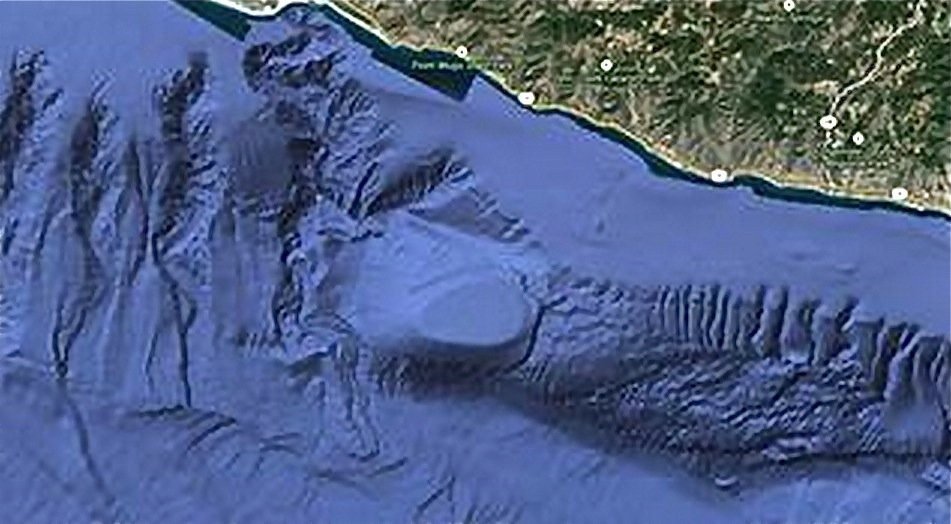
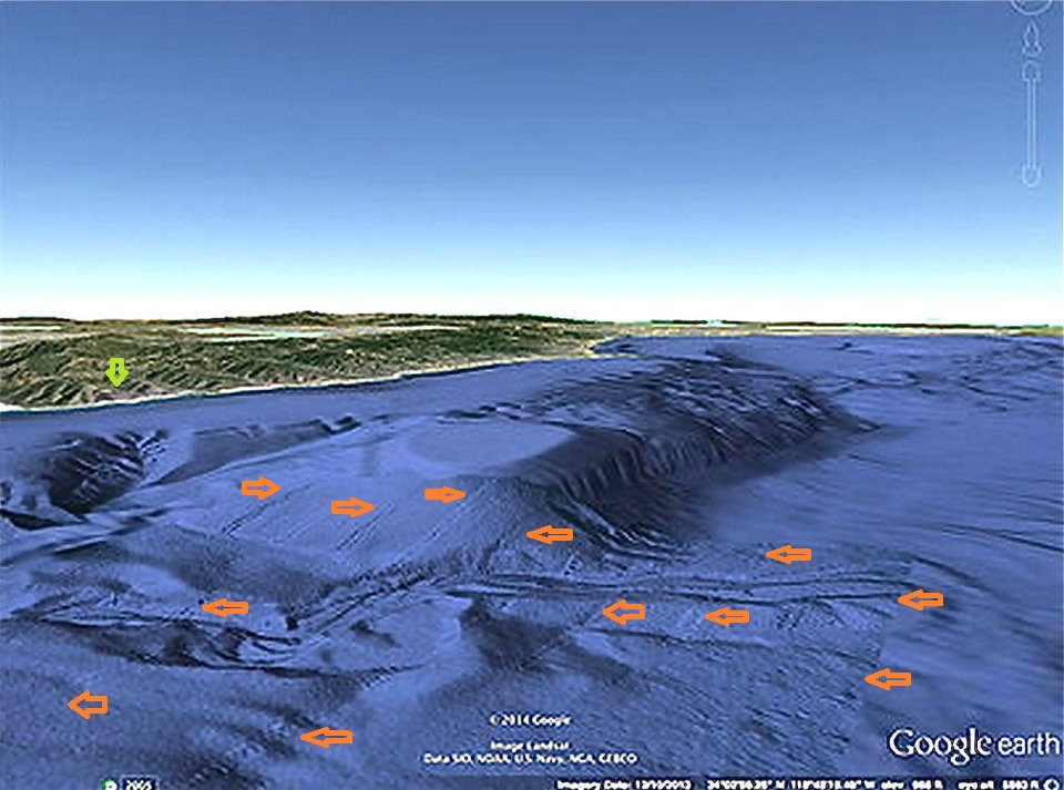
Close-up of the triangular pavilion looking toward the south. But note how the spaced lines in the sands
in foreground of the pavilion look patched-on like a layout-cover of alternating smooth and rough regulated lines, orange
arrows, which create a mowed appearing landscape area. When one looks closely, the terrain surrounding the pavilion
resembles sorry 'cut and paste' PhotoShop imagery. The light green arrow denotes the Point Mugu State Park. But why
the possible digital landscape cover? Are there more unique structures to be found in the immediate area? It is classified as a
protected Naval testing area.
Some Point Mugu Naval Base information here
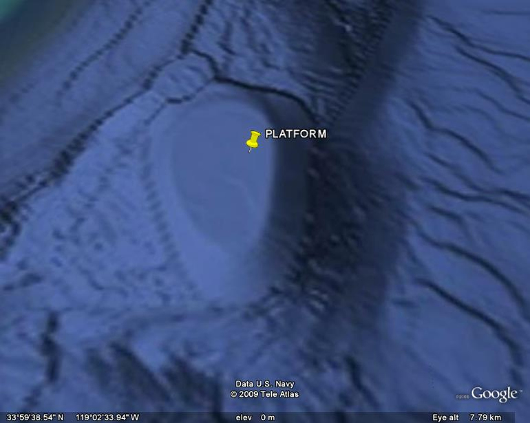
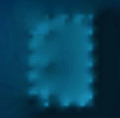
Looking directly down at the platform tarp on the pavilion there appears to be hundreds of pillars or
roofing beams in symmetrically aligned rows on the east, toward the beach side of the pavilion, almost as if a once roofed
pavillion extended down the coastline for miles. They do not appear to be erosion lines, but ceiling or roofing supports.
Note the top points of the platform's pillars around the edge of the 'tarp'. There also appears to be a
small round pavilion sliding down the north-west slope at the front corner of the large pavilion, and a narrow, elongated
diamond shaped one a little further north just under the vertical white measuring line shown by NOAA. Or, is it real 'erosion'?
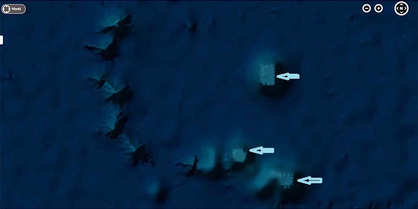
Some of the same pavilian-like shapes and pillars can be seen from different angles in different photos, although there are
varying distortions. The underwater structures in the middle of the Pacific Ocean are built identical and are rectilinear
and one octagonal or polygonal. See below.
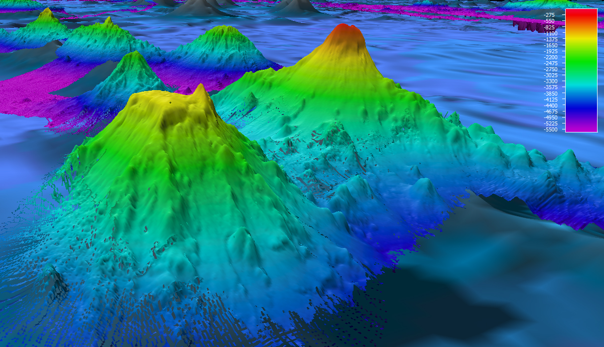
These are very large pillard appearing pavilions sitting on seamounts (volcanic cones) in the middle of
the Pacific ocean east of the Hawaiian islands. Looking down they appear rectilinear, and one octagonal or polygonal with the same pillars and 'tarp-like'
tops, looking similar to mesas covered with sand, and structured identical to the pavilion at Point Mugu in Malibu California.
The photos do have a 'blurry layer' as if in an attempt to hide them from clear view. There is a wall-like array of pyramid'ish,
volcanic cone-shaped mountains flanking them on the left that do not have blurred-covers.
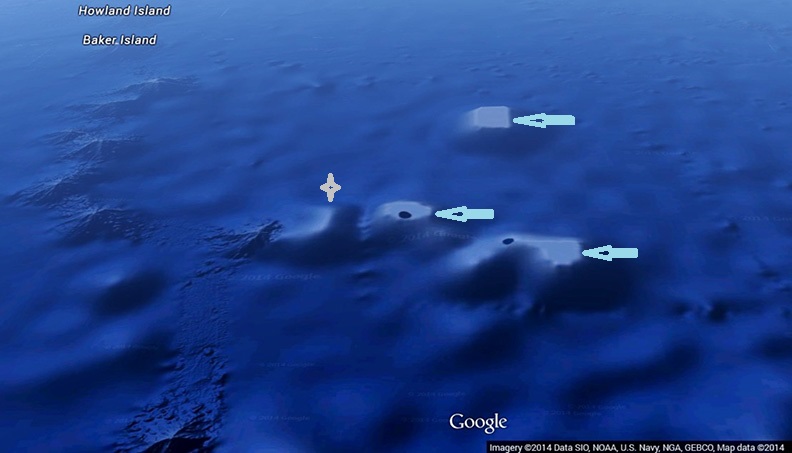
These structures aqua arrows are not 'cut-out' and paste PhotoShop graphics, but actual building
structures, along with others in the area like them, and a questionable L-shaped mount grey arrow beside them. The
large rectangular pavilion, upper right is twenty miles long and five miles wide, and the structure on the lower right is
about half that with a porch-like out-crop similar in shape to ancient Greek temples. They also appear to be hundreds of
feet in height like the Malibu structure, and are perched atop miles-high seamount pinnacles. The black spots on top actually
denote the blurred 'cover'. The pavilion on right appears to have a massive sand-covered-ramp or stairway leading to the top.
The octagonal/polygonal one on its' left might have the same.
These structures may have originally been built high atop mountain peaks on land or at sea when a large portion of the ocean was
tied up as glaciers that covered two thirds of the earth during the major ice age according to ancient Sumerian writ,
which also described a light, sunny section in the middle as the other third. These seamounts were discovered in 2004
by satellite, and later designated as the Phoenix Marine Reserve in 2008.
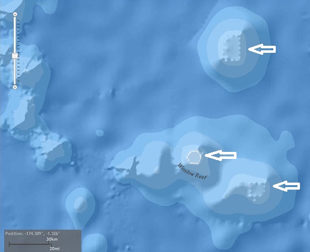
The un-named structure, top left, is twenty miles long by five miles wide, depicted atop the flat, yellow
seamount in foreground of the multibeam bathymetry image below, and denoted by the downward white arrow, appearing like
an undersea Mt. Olympus or Greek Parthenon.
These flat-topped pavilion-like 'mesas' are considered very odd in comparison to the other sharply pointed seamounts in the area,
and the particular three depicted with white arrows, still remain un-named. The flat-top structure, above right, is about
half the length of the left, with a similar width and has what appears to be an enormous stairway or mountain-like ramp
flanking it's far left side.
A ten year plan of deep-sea dives was planned, with a follow-up dateline for late 2017 to identify the special geological
areas of each seamount from the base of the sea floor at about 20,000 to 1,600 feet, or 6,000 to 500 meters below sea level,
along with the study of biological deep-sea marine habitats. All ocean Map Photos above and below courtesy of NOAA; OER,
U.S.Navy.
The topographic map just above shows the pavilions to be high atop a chain of seamount peaks near Baker and
Howland Islands. Pavilions are shown with white arrows The pavilion near bottom on right has the large porch-like out-crop
and giant ramp or stairway at it's left. The seamount to it's left is Winslow Reef which has the octagonal, or polygonal structure
on top.
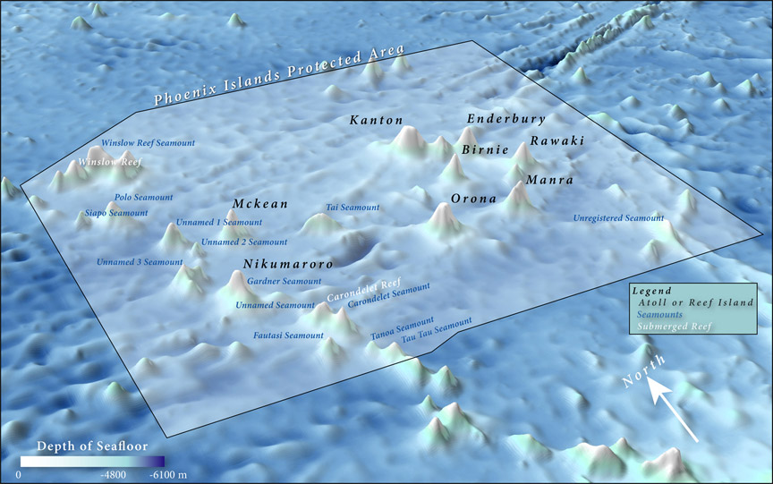
These sea mounts are situated in the middle of the Pacific Ocean within UNESCO's World Heritage site of the Phoenix
Islands Protected Area. It is not only whales, fish, and other sealife, along with indigenous islanders' ways of life that
are being protected here, but these secret archaic geo-structures from earth's extremely ancient past. There are more seamount
structures in this area which are not shown here -- at this time. Because of its small size the map below does not denote
any flat seamount structures, but only shows a basic outline of the Phoenix Islands Protected Area, UNESCO's deepest and
largest World Heritage Site.
One wonders if alleged archaic giants built the gargantuan structures atop these cone shapped pinnacles
using gargantuan machinery during the ice age? Or were they perhaps constructed during the beginning of the ice age melts
with the anticipation of high rising floods, or after the many major cataclysms which helped bring on the ice age melts?
There are also gargantuan stone walls off Japan's Yonaguni underwater ziggurat. What do you think?
 Mystery Faces